 If you’re going on a two-week vacation, you can do all your detailed research beforehand, and come up with a plan. But if you’re going for a year, you can’t anticipate all the places you’ll go, search out every detailed destination, and map out an itinerary. Or perhaps you shouldn’t even try; Jonathan Raban, in his essay “Why Travel?”, says:
“Yesterday’s creature of duty and habit is today’s creature of accident – a free spirit, a traveller, open to adventure as the dictionary defines it, That which happens without design; chance, hap, luck. Travel in its purest form requires no certain destination, no fixed itinerary, no advance reservations and no return ticket, for you are trying to launch yourself onto the haphazard drift of things and put yourself in the way of whatever chances the journey may throw up.”
I had sometimes travelled that way in the past, when I was single: I’m going to northern Europe, and when it starts to get cold, I’ll probably go to southern Europe. But in Raban’s estimation, all real travel like this has to be undertaken alone: “For this kind of pure, serendipitous travel is a solitary vice. Going with a companion is cosy, but you might as well be going with a coach party…. Adapting Clausewitz, travelling in pairs and families is the continuation of staying at home by other means.” I agreed with him completely when I was young, and found that even if I came across a simpatico friend while travelling, it was better if we went our separate ways during the day and just met up for dinner. If I was excited about the place where I was, I just didn’t want to compromise with anyone on how to spend my time – it was a too rare and distant adventure to not completely indulge my own instincts and manias.
This all changed when Linda and I were married, and came to a head 15 years ago, when we were on a 10-day bus tour through Sweden and Finland with American architecture students, run by the DIS school in Copenhagen. I found myself getting antsy and impatient , and realized that not only had I never travelled with students, or on an organized bus tour, but I had never really traveled with another person. My attitude completely changed six years ago, when Linda and Greta and I took a two-week roadtrip through northern California. I discovered that having to accommodate the likely interests of an eight-year-old wasn’t a problem, it was a pleasure, and it opened me up to seeing the world in a new way, and appreciating things I would not have given a second glance otherwise. It was the best trip of my life, and much of the pleasure came from sharing things with the girls. I still appreciate Raban’s insights, but I think he’s a bit more of a misanthrope than I am.
As we began to think about this trip, I knew I’d have to make more definite arrangements with Greta in tow than if I were alone – it’s harder to imagine showing up late at night in a strange city with no idea where you’re going to sleep. So I took an approach not unlike that of designing a building – you initially map out the big moves, and then you get more detailed as you change the scale at which you’re working.
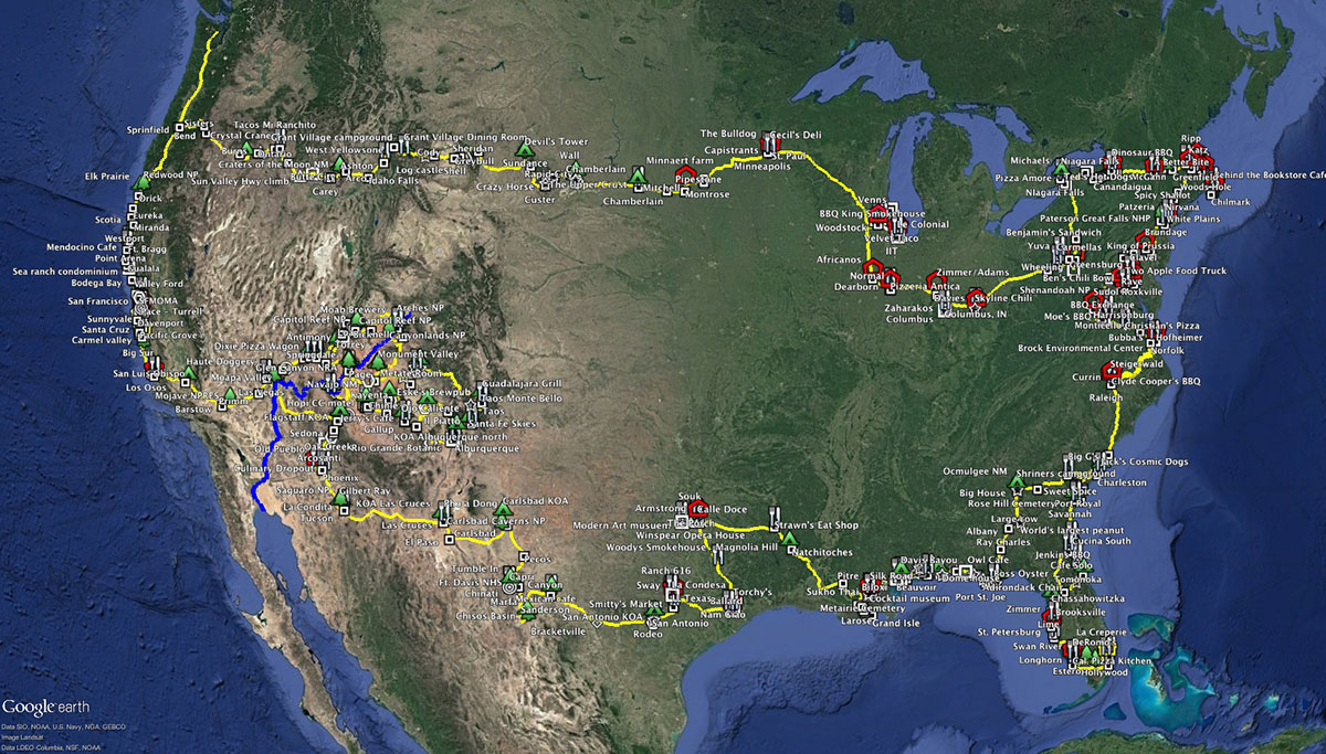
I used Google Earth to plan the trip – it allows you to plot and classify your own spots (Placemarks, they’re called) and routes, coding them with icons and turning layers on and off as suits your needs at the moment. It’s a way of jotting down notes about what you want to visit, and you can then see how they relate spatially to other places and possible routes. As we travelled, it also allowed us to plot all the places we did visit and roads we’d driven – we now have a complete cartographic record of our trip so Greta can start with that when she recapitulates this trip with her own kids in 30 years (her idea, not mine). If you’re interested in a copy of this data to jump-start your own trip planning, just let me know and I’ll send you a copy. But this doesn’t guarantee that all our friends will let you camp in their driveways. 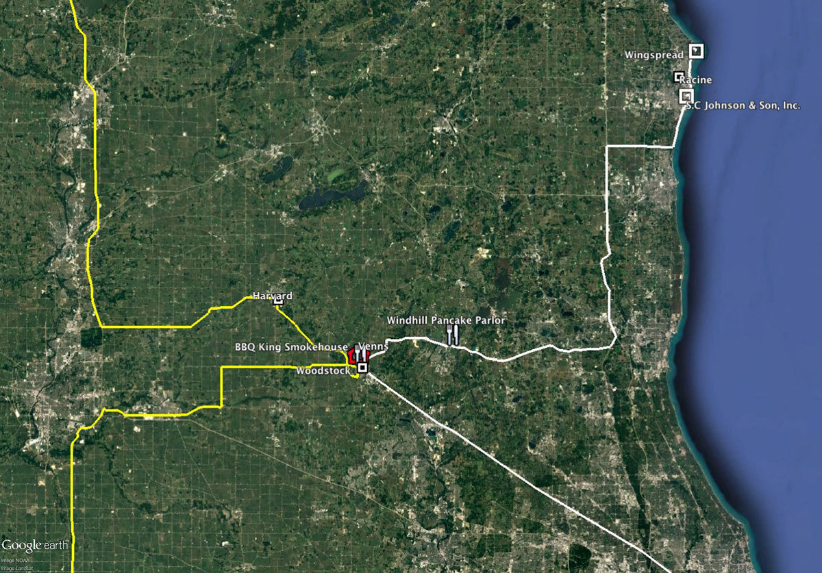
The first thing I mapped was where all of our friends and family lived. That gave us around 50 preliminary destinations (of which we visited 37, once we decided to skip the middle of the country). The big determinant for our schedule was the weather – we’d be travelling through the fall, winter and spring, and we wanted to be in places where the temperature and precipitation would allow us to be outside for much of the day. I looked at monthly average high and low temperatures, and developed a chart which showed those parts of the country where the daytime temps were in the 50s or higher, and the nighttime lows were usually above freezing: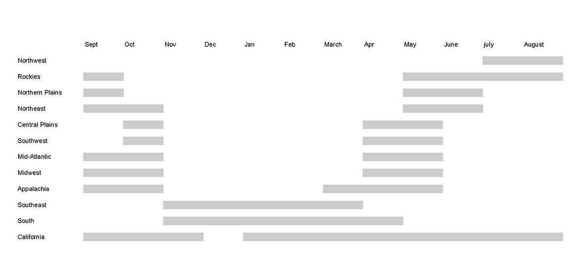
This chart revealed a few big determinants: in the summer, you want to be in the Northwest or the Rockies. In the winter, you want to be in the South (and not too far north of the Gulf). Every place else in the country is best visited in the fall or spring, except California, which is perfect all the time. I then analyzed two scenarios – a clockwise loop and a counterclockwise loop. Starting from the Northwest in the fall, a clockwise loop worked best. (In Texas we met a couple from California who started in the winter, in which case a counterclockwise loop was better.) So given these parameters, our initial, big-picture plan was:
- September: across the country
- October: the Northeast
- November: down the East Coast
- December: the Southeast (including family in Florida at Christmas)
- January: the Deep South
- February: Texas to the Southwest
- March: the Southwest
- April: the Colorado Plateau
- May: California
- June: home
We pretty much stuck to this, except that we got going two weeks later than expected (as it took so long to find the trailer); when we were in the Northeast, the weather was 10 degrees warmer than normal, so we took our time heading down the coast; and when Glen pointed out that Mardi Gras was only a week away, so there was really no point in our hurrying out of New Orleans.
Since we usually don’t have the truck when we are out of the Northwest, this shaped our itinerary too, skewing it towards places which you really can’t reach without a vehicle. So instead of spending more time in places like New York (where having a vehicle is a negative), we allocated more time to places like Cape Cod or Harpers Ferry – places unlikely to be destinations on their own, or to which we would fly. We were also biased towards places we will probably not go to again for a long time – Florida is a common destination to see family, but Charleston is just too far off the beaten path.
As I looked over the list of possible destinations and estimated how much time we might want in each, I told Linda that we really needed two years to do this trip. She said, “You get one”. So even thought we covered a lot of the country, there were still important places that didn’t make the final cut. As we drove through Seneca Falls, Ithaca was 40 miles away at the other end of Cayuga Lake. We looked at the clock, and kept driving on to Syracuse. It was the closest I’ve ever gotten to the Cornell campus, but it still wasn’t close enough, and I’m starting to doubt that I’ll ever get there.
I discovered that there are some big geographic facts that are not apparent in advance, For example, the distance on the Colorado River between Moab and Las Vegas is about 450 miles, and there is only one place in that whole length where you can drive across it – the Glen Canyon Dam outside Page.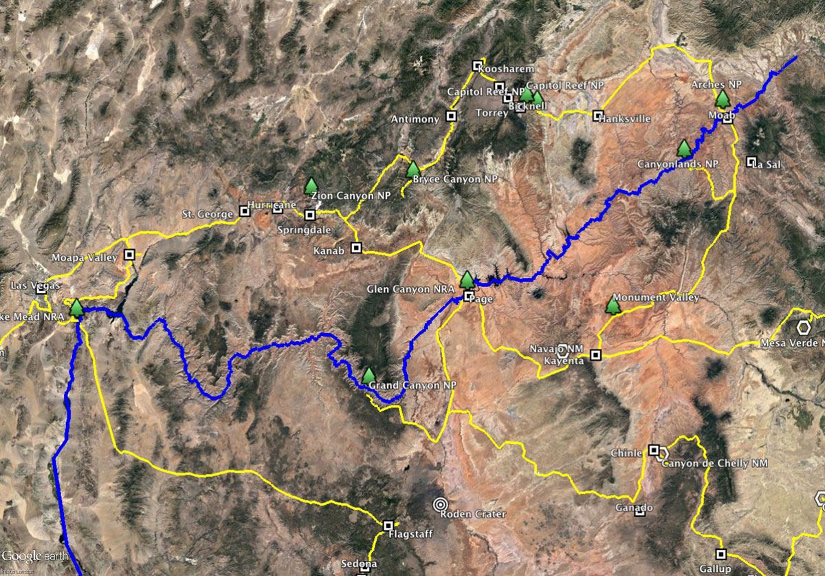
I also hadn’t realized (until I started searching for routes) that it’s essentially impossible to cross the Sierras for most of the year, anywhere between Bakersfield and Sacramento, 300 miles apart. When you mention these hard-won insights to locals, they look at you like you’re crazy, probably because they’re just so obvious (like not knowing that you have to transfer from the 2 or the 3 to the Broadway Local at 96th, otherwise you end up in Harlem instead of at Columbia).
As we approached a region, I’d start doing more detailed research about a month in advance. What cities did we want to visit, what were specific museums, buildings, parks, sights, restaurants etc. We’d alert our friends in the area with our rough plans and see if those dates worked for them.
Finally, I would start planning our itinerary in detail about a week out – how many days to spend in a specific city or National Park, was there a good campground for which we needed to make reservations, what days were the museums closed, where was the best barbecue? All of this research took a lot more time than I expected, and it was one of the main reasons to stay in a commercial campground, so we could search on the internet for places and attractions.
This method also allowed us to adapt to changing conditions, such as the weather, which we did quite often (including completely changing direction twice at the last minute in the Southwest). As we were about to leave Monument Valley, I saw that the forecast had changed, so I looked at the ten-day forecasts for nine locations, plotted them in a matrix and then shaded the cells where we didn’t want to be, with boxes representing our possible trajectories. So instead of following our original plan of Mesa Verde to Chaco Canyon in this period, we hung out at a low elevation in Page for three days to let the snowstorm go by, then headed to the Grand Canyon and on to Hopi, Tsegi and Chaco from the other direction.
There were some online resources that helped at this detailed level too, such as Roadside America, with its state-by-state maps of kitsch and Americana. We wouldn’t have gone too far out of our way to see the life-sized, revolving Ray Charles music box in his hometown of Albany, GA, but once we had a basic route roughed out, it was easy to look at our kitsch options and diverge from the straightest path to check this one off.
When we did get to a place, the best recommendations always came from friends – we were given great tours of their cities by many of them. How else would we ever have found the Windhill Pancake Parlor (where breakfast dishes are delivered on a toy train) if Aaron and Heather hadn’t taken us?
That became our modus operandi – we always knew our general direction, and we’d often have a destination or two planned and a campground reserved, but when it came down to immediate activities, we just played it by ear. Many mornings, Greta would wake up and ask me, What are we doing today? And I’d say, I don’t know, what do you feel like doing? That usually worked out fine, and maybe Jonathan Raban would have approved.

Amazing to read how you planned your trip. When are you doing Europe? How is Greta adjusting to learning in classroom again instead of on her feet?
LikeLike
Europe may be reasonably soon – if we can figure out how to get the Scamp on a plane we’ll come camp in your driveway! Greta is doing okay with school – some of it is still boring, but much of it is better, she’s back wth all her friends, and she’s joined the choir and the robotics club, and is playing ultimate frisbee. She’s probably more re-adapted than me.
LikeLike